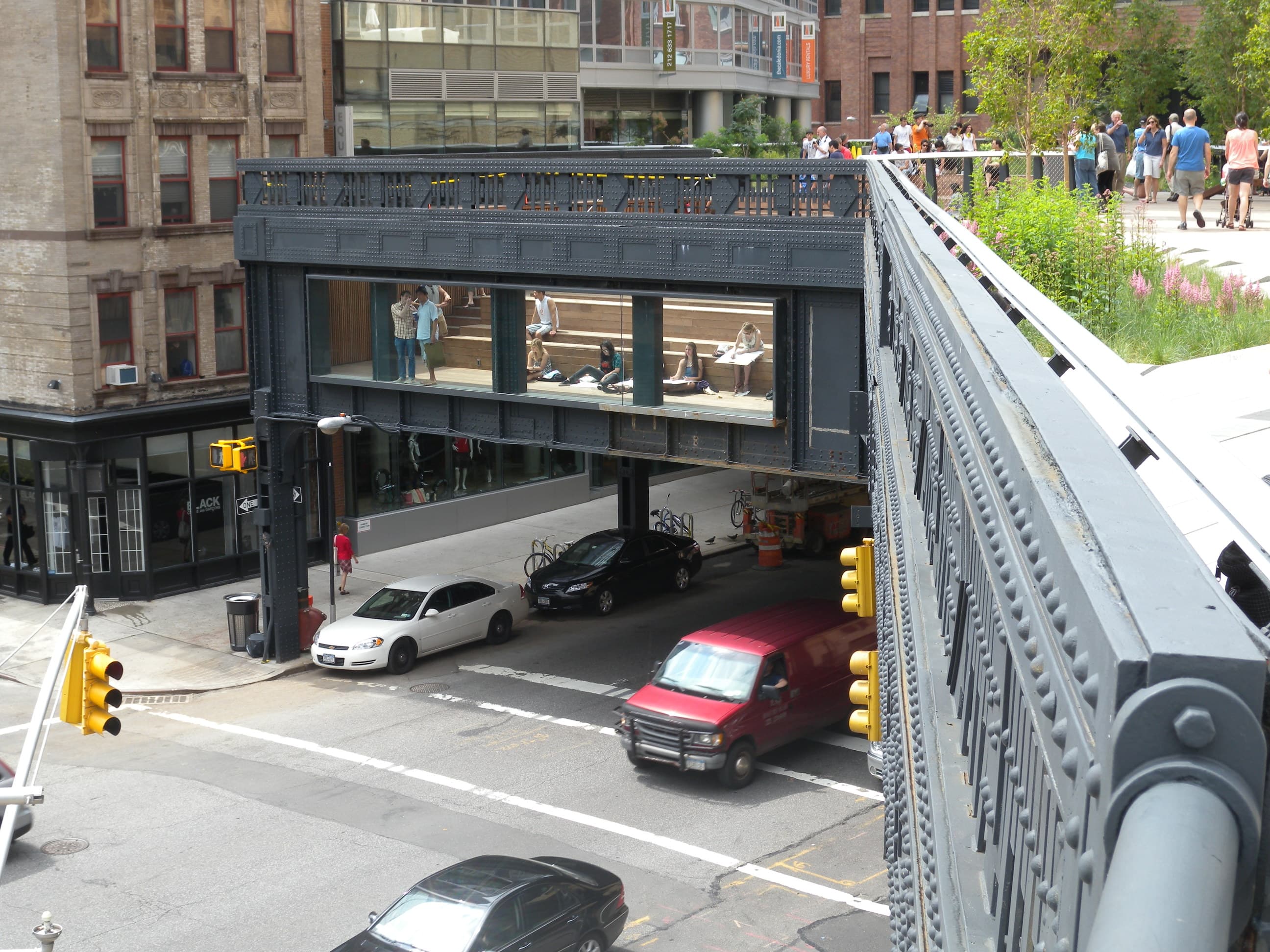
The High Line.
Policy bed matters more than the structure.
the corridor before
Before
The High Line story begins with pedestrian death, not parkland. From 1847 onward, the New York Central Railroad ran freight trains at street level up Tenth and Eleventh Avenues on Manhattan’s West Side, hauling coal, beef, and dairy alongside playing children and pushcart vendors. Locals called the corridor “Death Avenue.” By 1910, one organization estimated 548 deaths and 1,574 injuriesalong Eleventh Avenue over the prior decades; the Bureau of Municipal Research had documented 436 deaths since 1852, including roughly 200 in the decade preceding 1908 — “mostly of children.” The railroad’s stopgap was a troop of mounted “West Side Cowboys” who rode in front of the trains waving red flags. They patrolled until 1941.
The political pressure to lift the tracks above the street took eighty years to translate into concrete. In 1929 the City of New York, New York State, and the New York Central Railroad signed the West Side Improvement agreement — a 13‑mile project conceived in part by Robert Moses that eliminated 105 grade crossings, added 32 acres to Riverside Park, and built both the West Side Elevated Highway and the elevated freight viaduct now known as the High Line. The viaduct was dedicated June 29, 1934, at a cost of roughly $150 million in 1934 dollars — about $2.81 billion in 2025. It ran 1.5 miles along Tenth Avenue, 25–30 feet above the street, piercing the second floors of warehouses so freight could be unloaded directly onto factory floors.
For about forty years it worked. Then the trucking industry took the work. By the 1960s the southernmost segment had been demolished. Conrail inherited what remained in 1976 and stopped using most of it almost immediately. The last train ran in 1980 — a three-car consist carrying frozen turkeys, per the official history.
What followed was a twenty-year limbo that mattered enormously for what came next. Chelsea and the Meatpacking District in the 1980s were a long way from the gallery-and-boutique strip they became after 2009. The Meatpacking District was still actually packing meat: in 1985 the area had roughly 250 meatpacking businesses; by 2003, fewer than 35 remained. Chelsea was art-warehouse, light-industrial, and home to two large NYCHA developments — the Fulton Houses and the Chelsea‑Elliot Houses — built in the 1960s explicitly to keep working-class New Yorkers near their West Side jobs. The neighborhood was redlined, predominantly Black, Latino, and white working-class, and quietly affordable.
Above the streets, the viaduct rusted, and an unsanctioned meadow of wildflowers grew on the rail bed. The structure had powerful enemies. Adjacent property owners wanted it down — they argued, correctly, that the viaduct cast shadow, blocked views, and depressed land values. The Interstate Commerce Commission approved demolition plans in 1992. Mayor Rudy Giuliani, in his final days in office in December 2001, signed an order authorizing demolition — “one of his last acts in office, two days before he left,” in the language of period reporting.
Two things saved the structure during these years. The first was a Chelsea resident named Peter Obletz, a train enthusiast who in the early 1980s tried to buy the viaduct from Conrail for ten dollars to restart freight service. Conrail accepted — demolition would have cost five million dollars — but the federal Department of Transportation overturned the sale in 1987. Obletz lost the case but bought time. The second was that CSX Transportation, which absorbed Conrail in 1999, chose to explore repurposing the viaduct under the federal Rails-to-Trails Conservancy program rather than fight the demolition order.
That CSX decision became the spark.
decision, timeline, cost
Build
On July 25, 1999, the New York Times ran a feature about CSX commissioning the Regional Plan Association to study the High Line’s reuse, alongside the political question of whether to demolish it. Two Chelsea residents who did not know each other — Joshua David, a freelance travel writer, and Robert Hammond, a self-taught art consultant — read the article independently. Both attended the Manhattan Community Board 4 meeting that summer where CSX and the Regional Plan Association presented the reuse study. They were the only two attendees who spoke against demolition. They exchanged business cards. By October 1999 they had incorporated Friends of the High Line.
David and Hammond’s organizing strategy is worth describing because it is unusually transferable. They photographed the viaduct from the inside — most New Yorkers had never seen the top — and built a public-facing visual case. They commissioned an economic-impact study showing that incremental tax revenue from higher adjacent property values would more than cover the cost of the park. They recruited celebrity neighbors — Edward Norton, Diane von Furstenberg, and Barry Diller chief among them — for both money and political cover. In 2000, they visited the Promenade Plantéein Paris, the only existing model: a 4.7‑kilometer linear park, partly elevated on the former Vincennes railway viaduct, inaugurated in 1993. They returned with a working model in hand.
Then the mayor changed. Michael Bloomberg took office in January 2002 and made the High Line a personal priority within weeks, reversing his predecessor’s demolition order. The Bloomberg administration filed with the federal Surface Transportation Board to railbank the corridor — the legal mechanism under the National Trails System Act that keeps a rail line theoretically available for future freight while permitting interim trail use. This step is what made everything else possible. The executive-political-will dimension matters for Saint Paul: a park on contested infrastructure does not get built without a mayor willing to spend political capital on it.
In January 2003, Friends ran an open international ideas competition — 720 entries from 36 countries, ranging from a giant lap pool to a roller coaster to a series of wildflower meadows. In 2004, Friends and the City selected the design team: landscape architects James Corner Field Operations, architects Diller Scofidio + Renfro, and Dutch planting designer Piet Oudolf. That team’s central move was to honor the wildflower meadow that had grown on the disused rails — a designed “agri-tecture” that quoted the ruin it replaced.
On June 23, 2005, the New York City Council approved the rezoning of the Special West Chelsea District. This is the policy decision that, more than any other, shaped what happened next — and it is the one most often skipped in celebratory accounts. The rezoning lifted long-standing M1‑5 light-manufacturing restrictions on roughly 13 blocks adjacent to the viaduct, allowing mixed commercial and residential development with significant density bonuses. The community board and tenant groups asked for 30 percent mandatory permanent affordable housing throughout the district. The final compromise, brokered by Council Member Christine Quinn, projected only 27 percent affordable units — and it was not mandatory. The plan gave developers a “High Line density bonus” they had to use first, before they could access an additional bonus for building affordable housing. Affordable was the secondary lever, not the primary one. This is the policy bed.
On November 7, 2005, the federal Surface Transportation Board issued the Certificate of Interim Trail Use; title transferred from CSX to the City of New York. Construction began April 2006. Section 1 — Gansevoort Street to West 20th Street — opened June 8, 2009. Section 2 opened June 7, 2011. Section 3 opened September 21, 2014. The Spur, a final eastward extension, opened June 5, 2019. The Moynihan Connector to Penn Station opened June 22, 2023.
Cost. The first two sections cost $152.3 million, of which the City contributed $112.2 million, the federal government $20 million, New York State $400,000, and Friends of the High Line raised the balance (approximately $19.4 million) from private donors. Section 3 cost approximately $76 million; the Moynihan Connector approximately $50 million. Total investment across all phases is in the range of $260–290 million in nominal dollars.
the arc through 2026
Compound
By any conventional civic metric the High Line has succeeded. Visitor counts grew from roughly 2 million in 2009 to nearly 5 million by September 2014 to 8 million per year by 2019. Roughly 80 percent of those visitors are tourists, not New York residents, per a 2019 study of park users — a fact that becomes important to the displacement story. NYC tourism overall surpassed pre-pandemic levels in 2024 with nearly 65 million annual visitors citywide; the High Line’s post-pandemic numbers are believed to be back at or near the 8‑million benchmark, though Friends of the High Line has not released updated annual figures publicly.
Property values within a short radius of the viaduct rose roughly 35.3 percentin the immediate aftermath of Section 1’s opening compared to a control set of comparable Manhattan properties. Within five years, the City was attributing approximately $2 billion of new investmentto the surrounding West Chelsea zone. Incremental property tax revenue to the City through 2027 is estimated at $1.4 billion — roughly $65 million per year, more than 900 percent of the City’s capital contribution. Adjacent property owners — the same group that had wanted the viaduct demolished a decade earlier — captured the lion’s share of that uplift.
The High Line is operated under a license agreement between Friends of the High Line and the New York City Department of Parks & Recreation. Under that agreement, Friends raises and contributes the overwhelming majority of the park’s annual operating and maintenance budget — described by the organization as roughly 98 percent of a $14‑million-plus annual operating budget. Friends of the High Line Inc reported approximately $20.97 million in revenue in 2023 per public Form 990 filings. This conservancy-plus-Parks model is now the de facto national standard for high-design public space.
The High Line’s influence on the field is substantial. In 2017, Friends of the High Line founded the High Line Network — initially 19 infrastructure-reuse projects from across North America, expanded to 47 by February 2023. Member projects include Chicago’s 606 / Bloomingdale Trail (opened 2015), the Atlanta BeltLine (22-mile loop, in active construction), Philadelphia’s Rail Park, Houston’s Buffalo Bayou Park, Toronto’s Bentway, Detroit’s Dequindre Cut, San Antonio’s Hemisfair, and others. The Network publishes a Community First Toolkit, developed in partnership with the Harvard Graduate School of Design and the Urban Institute, that is now the field’s primary equity-planning resource.
The comparison cases inside the Network tell the same story. Chicago’s 606, a 2.7-mile elevated rail-trail that opened in 2015, saw home prices along its western portion climb 344 percent between 2012 and 2018— from a median sale price of $97,000 to $462,000. Logan Square saw the largest Hispanic population decline of any community area in Chicago during that period. The Atlanta BeltLine, originally projected to deliver 5,600 affordable units by 2030, had delivered roughly 3,555 by 2023 — and housing values within half a mile of the trail have risen 17.9 to 26.6 percent more than the citywide average.
The Coulée verte René-Dumont in Paris — the project that inspired the High Line — has not produced comparable displacement, in large part because the 12th arrondissement is governed under France’s national rent-regulation framework and the encadrement des loyers municipal cap, and Paris in 1993 made no analogous rezoning bet. This is the structural finding: the elevated park is not the gentrifying force. The elevated park plus a permissive land-use rewrite is the gentrifying force.
what happened to people
Residential impact
This chapter is load-bearing for Saint Paul. The High Line is the canonical eco-gentrification case study in the urbanism literature, and any precedent argument that elides it is dishonest. The findings that follow are drawn from peer-reviewed work, institutional research, and the kind of period journalism that captured the displacement as it was happening — not after.
The peer-reviewed anchor is Kevin Loughran’s 2014 paper, “Parks for Profit: The High Line, Growth Machines, and the Uneven Development of Urban Public Spaces,” published in City & Community. Loughran argues that public spaces in the era of neoliberal urbanism exist on a continuum of privilege: elite privatized parks like the High Line on one end, neglected and over-policed parks on the urban periphery on the other. The High Line, in Loughran’s account, was constructed as a consumption amenity for what he calls “the new urban middle class.” Loughran expanded the argument into a book-length treatment, Parks for Profit: Selling Nature in the City, Columbia University Press, 2022.
Black and Richards’s 2020 paper in Landscape and Urban Planningfinds that adjacent housing values rose 35 percent post-opening, and that the demographic profile of immediately adjacent census tracts shifted significantly toward higher-income, younger, whiter, and more educated residents. Lang and Rothenberg’s 2017 paper in Environment and Planning A extends the growth-machine framework to argue that the High Line functioned as a vehicle for the 2005 Special West Chelsea District rezoning rather than the other way around.
At 26th and Tenth, the Chelsea-Elliot NYCHA houses — median household income around $21,000— face the Avenues: The World School, a private K–12 with tuition between $40,000 and $50,000.
— Class Divide (2015), dir. Marc Levin
Within a five-minute walking distance of the High Line, median market value per square foot rose 103 percent between 2003 and 2011— per the NYU Furman Center. Chelsea census-tract median household income rose from roughly $80,747 in 2009 to roughly $141,672 by the late 2010s, a jump of approximately 23 percent above the citywide growth rate of about 7 percent over the same period. The Chelsea-Elliot Houses and Fulton Houses NYCHA residents did not move; they were not gentrified out of their units, because their units are public housing. They became, instead, residents of an enormously richer surrounding neighborhood whose grocery stores, laundromats, bodegas, and family-owned restaurants had been replaced by boutiques and tasting menus that priced them out of the everyday neighborhood economy.
Small business displacement is documented in the period press: the long-running automotive shops, hardware stores, and meatpacking businesses along Tenth Avenue and the cross streets were almost entirely replaced between 2009 and 2016. The galleries that had moved to Chelsea in the 1990s as a refuge from SoHo rents began their own exodus to the Lower East Side, Tribeca, and Brooklyn by 2015 as commercial rents tripled.
Robert Hammond, the co-founder, has been unusually candid. In a 2017 CityLab interview he said, of the residents around the park: “We wanted to do it for the neighborhood. Ultimately, we failed.” He clarified later that he meant “we could have done better at addressing social equity issues from the start.” His most-quoted formulation, from a separate interview, runs:
The biggest lesson… is you have to capture the value before you create it. Once you create it, you can’t get it back.
— Robert Hammond, co-founder
That principle — capture value before you create it — is the founders’ single most actionable lesson, and it is exactly what the 2005 West Chelsea rezoning failed to do. The density bonus the City handed developers was given away upstream of the park’s completion, before anyone could measure the windfall it was about to deliver. By the time the windfall arrived, the developers held it and the City did not have the legal mechanism to recapture it for affordable housing.
The High Line Network’s published response — the Community First Toolkit— is the field’s first attempt at distilling that lesson into something other practitioners can use. Developed with the Harvard Graduate School of Design and the Urban Institute, launched 2022, it walks new infrastructure-reuse projects through an equity-based action-planning framework. It is not a regulatory document — it is a peer-reviewed planning resource, and it explicitly names the 2005 West Chelsea rezoning as the project’s central regret.
for Saint Paul
The lesson
The High Line teaches Saint Paul one structural lesson, several tactical ones, and one local-context advantage.
The structural lessonis that the elevated park does not cause displacement on its own; the elevated park combined with a permissive land-use rewrite causes displacement, and the rewrite is the variable. Paris’s Promenade Plantée — the project the High Line itself cites as inspiration — produced no comparable displacement because Paris had national rent regulation and made no analogous rezoning bet.
The tactical lessonsare Hammond’s: capture value before you create it; ask residents what they need before you ask designers what they imagine; build the operating conservancy with an equity mandate written into its license from day one.
The local-context advantage is that Saint Paul, almost uniquely among American cities considering linear-park reclassification, already holds the policy bed the High Line did not:
- The rent stabilization ordinance approved by Saint Paul voters in November 2021, which caps annual residential rent increases at 3 percent (refined by Council in September 2022 and May 2025).
- The 4d Affordable Housing Incentive Program, which to date has preserved more than 3,000 naturally-occurring affordable units under 10-year affordability commitments with 20 percent of units restricted at 50 or 60 percent of Area Median Income.
- The SAFE Housing Tenant Protections Ordinance and its uniform screening criteria + capped application fees.
- The three-month protection period when affordable buildings change ownership, plus relocation assistance.
Chelsea in 2005 had none of those instruments. Saint Paul in 2026 has all of them.
— the case Saint Paul gets to make
Reclassifying the Skyway as a Linear Park inside that policy bed is not the same act it would have been twenty years ago in Manhattan. It is the act the High Line itself, through its founders and through the High Line Network’s Community First Toolkit, has asked successor cities to perform.
Sources & further reading
Where this came from.
- Black, Kristian J., and Sarah J. Richards. Eco-gentrification and who benefits from urban green amenities: NYC's high Line — Landscape and Urban Planning (2020)
- Loughran, Kevin. Parks for Profit: The High Line, Growth Machines, and the Uneven Development of Urban Public Spaces — City & Community 13(1): 49–68 (2014)
- Loughran, Kevin. Parks for Profit: Selling Nature in the City — Columbia University Press (2022)
- Lang, Steven, and Julia Rothenberg. Neoliberal urbanism, public space, and the greening of the growth machine: New York City's High Line park — Environment and Planning A (2017)
- History — The High Line
- The History of 'Death Avenue' — The High Line (2021)
- A Note from Robert Hammond — The High Line (2017)
- Special West Chelsea District Rezoning and High Line Open Space FEIS — NYC Planning
- High Line/Chelsea Rezoning Gets Go Ahead — CityLand (NYLS) (2005)
- The Other High Line Effect: How NYC's Glitziest Park Spread Extreme Inequality — Fast Company (2016)
- The End of the High Line Era — Fast Company (2017)
- Alexander Prescott. The High Line is Smothering Chelsea — Roosevelt House Public Policy Institute, Hunter College (2016)
- Changing Grid: Exploring the Impact of the High Line — StreetEasy
- Home Prices Along West End Of 606 Trail Up 344% Since 2012 — Block Club Chicago (2020)
- Atlanta's BeltLine Shows How Parks Can Drive 'Green Gentrification' — Route Fifty / The Conversation (2023)
- The High Line Network Tackles Gentrification — Architect Magazine
- Community First Toolkit — High Line Network
- Coulée verte René-Dumont — Wikipedia
- Rent Stabilization — City of Saint Paul
- 4d Affordable Housing Incentive Program — City of Saint Paul
- Tenant Protections — City of Saint Paul